


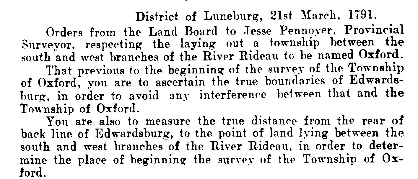
On March 30, 1791, 230 years ago, a young surveyor and work team set off from the St. Lawrence River to begin laying out a new township fronting on the West Branch of the Rideau River. His instructions had been issued on March 21 “to Jesse Pennoyer, Provincial Surveyor, respecting the laying out of Township between the South and West branches of the River Rideau to be named Oxford”. It was, for the residents of North Grenville, the beginning of their history as a community.
His instructions ordered Pennoyer to begin his survey at “the point of land lying between the South and West branches of the River Rideau, in order to determine the place of beginning the Survey of the Township of Oxford.”
The journey was far from straightforward for the group, having to bring along all the equipment necessary for the survey, including heavy measuring chains, food, and supplies, to last them during the weeks the survey was expected to take. They were joined by a second survey team led by Theodore Depencier, who was to make a survey of Marlborough Township, on the far side of the West Branch of the Rideau. The groups headed north from the Saint Lawrence and struck the South Nation River (then the La Petite Nation), which they found it difficult to ford. Two rafts they made sank, almost drowning members of their work team, before they managed to get across the river and arrived at the South Branch on April 3. After three more days, they completed another raft and a canoe and, as Pennoyer recorded, “prepared for setting off for the point between the two branches”.
Depencier had gone ahead, and encountered “very bad rapids” on the South Branch which obliged him to unload his rafts and carry them around the rapids. He tried to warn Pennoyer, but they could not stop their raft because of the current and “it went down the rapids with all the Provisions on it, but not without imminent danger, however we lost nothing”.
They continued on April 10 “about 8 miles past many dangerous and difficult places without any loss”, and the next day “brought the Raft and provisions round the point and up the West Branch about two miles and encamped. This would have located their camp around Beckett’s Landing. It was on April 25 that Pennoyer made this historic entry in his diary: “Made a Cabbin [sic] to secure the provisions, came down to the Point and began the survey of the Township of Oxford”.
The weather throughout this journey had been miserable, and it continued that way for much of the following months. It was not until July 14 that they took a break in order to travel to Gananoque to lay out 1,000 acres of land on behalf of Sir John Johnson, a leading member of the Loyalists who had been refugees from the American Revolution. He had moved to Gananoque after being passed over as the new Lieutenant Governor of Upper Canada.
Through the weeks between April and July, Pennoyer and crew had worked through rain, swamps and shortage of provisions, laying out the basic boundaries of Oxford Township. Day after day in his diary, Pennoyer noted: “it began to rain and continued raining all day”. Some days, the rain prevented any survey work being done at all, and those days that permitted surveying Pennoyer noted with such entries as: “there’s a bad cedar swamp”, “a very bad cedar swamp”, or “much difficulty being obliged to ford a swamp of considerable length, the water being about 3 feet deep and very cold.”
The nearest source of provisions was at Roger Stevens’ clearing which was located near the site of Merrickville and Burritt’s Rapids. The crew went there for provisions occasionally, and to sharpen their axes. Pennoyer’s health suffered also. On June 10 he reported that around noon “I was taken violently ill with a pain which obliged me to be still for the remainder of the day”. Then, on June 26, as he finished the last line of survey, he cut his leg “in such a manner as wholly disabled me from proceeding further”. He was unable to work, other than in preliminary sketches of the survey until July 14, when he left for Gananoque.
But the survey was not yet complete, and Pennoyer and party returned to the Rideau in September and completed the survey by October 1. It is almost impossible to imagine the conditions under which men like Jesse Pennoyer worked as he laid out on the ground and in maps the boundaries and concessions of townships like Oxford-on-the-Rideau. He worked at a time when the landscape, geographically and politically, was changing in historic ways. As he surveyed Oxford, the British Government in London was passing legislation to establish a new Province, to be called Upper Canada, the territory that would, in 1867, change its name to Ontario. Historic times and impressive achievements by those who came before us.


And my ancestor Lewis Grant surveyed the lands north of Gananoque, at about the same time.